Eta’s New Track Sends It Back Into Gulf Of Mexico
Just when we thought we didn't have to worry about another storm coming into the Gulf of Mexico, here comes Tropical Storm Eta.
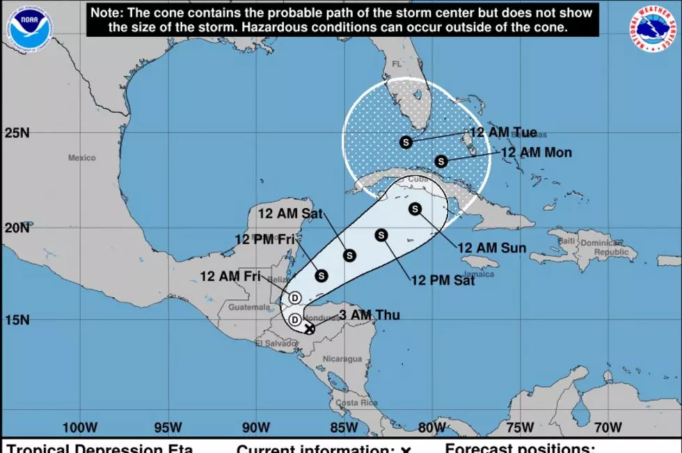
Then Hurricane Eta slammed into Nicaragua as a Category 5 storm packing winds over 150 miles per hour. It now sits over Honduras as a tropical depression with winds at 30mph. It has been sitting over the region for four days now, dumping unbelievable amounts of rain.
The National Weather Service has released an updated track for Eta, and friends, we are not liking the new forecast. Eta is supposed to move into the Caribbean around midnight on Friday, and the forecast track takes it toward Cuba. Then, the track shows after crossing over Cuba, it sets its sites on the Bahamas and South Florida.
What is wacky is what the storm is forecast to do once it gets close to the coast of South Florida. The forecast track shows Eta will then take an abrupt left and enter the Gulf of Mexico by midnight on Tuesday as a tropical storm.
That is when everyone who lives on the Gulf Coast will be on alert, especially for us living in Louisiana since we have been beaten and battered so much during this 2020 hurricane season. Let's hope that this track gets altered and it doesn't come into the Gulf. There is nothing to worry about currently, but it would be good to keep an eye on this storm.

The Impact of Hurricane Laura on Lake Charles
More From 92.9 The Lake