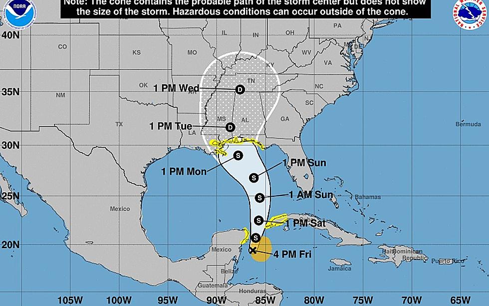
Alberto Update: Storm Surge Watch
The 4 PM CDT Friday, May 25, Advisory Bulletin No. 2 includes an updated watch for storm surge from the mouth of the Mississippi River to Horseshoe Beach, Florida. The National Hurricane Center also warned of heavy rainfall for the Yucatan Peninsula, Western Cuba, Florida and the open waters of the Gulf of Mexico.

Storm Surge Watch Map

Where and How Fast and How Much
Alberto is presently located about 85 miles SSE of Cozumel, the maximum sustained winds remain as earlier at 40 MPH with higher gusts. Movement is a slow 2 MPH due East at 90°. A slow and erratic drift toward the north is expected to occur overnight. By Saturday afternoon the speed should pick up in a more defined northerly pattern.
A Tropical Storm Watch is effective for Tulum to Cabo Cathoche, Mexico. The Cuban Province of Pinar del Rio, Indian Pass to Grand Isle and Lake Ponchartrain and Lake Maurepas.
The advisory mentions heavy rainfall with 4-8 inches on the eastern side of the storm by the time it reaches Florida and other northern gulf shorelines. Storm surge expectations could peak at 2-4 if they occur during a time of a high tide.
More From 92.9 The Lake

![Empty Gallon of Milk Could Come In Handy If Electricity Goes Out [PHOTO]](http://townsquare.media/site/34/files/2021/08/attachment-GettyImages-1257995328.jpg?w=980&q=75)