National Hurricane Center: 7 AM Tropical Storm Barry Update
Here's the latest tracking of Tropical Storm Barry and what it means for SWLA.
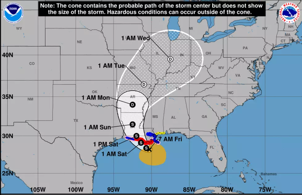
According to the 7:00am National Hurricane Center update, TS Barry is currently moving WNW at 5mph with sustained winds of 50mph.

If there's good news to take out of this update, it's that Barry is forecast to stay a tropical storm at landfall and not form into a hurricane.
You probably noticed that the track of the storm has moved more westward. With the predicted landfall not happening around Baton Rouge anymore, Barry could now be going straight through Lafayette.

Rainfall will currently be the largest threat to SWLA with some of our listening areas potentially experiencing 4-6 inches of rain with our outlying listening areas possibly getting around 6-10 inches.
According to the above model, Baton Rouge now has the largest predicted rainfall in the wake of Barry with a possible 15-20 inches of rain.
If you live along the Louisiana coast, we advise everyone to please be prepared for this storm. Have the proper supplies ready and evacuate if you feel it's necessary for you and your family. There's no such thing as playing it too safe.
Here are some more resources for you:
- TROPICAL STORM RELATED CLOSURES IN LAKE CHARLES
- HURRICANE PREPAREDNESS TIPS FROM SHERIFF TONY MANCUSO
- PREPARE YOUR HOME BEFORE A TROPICAL STORM/HURRICANE
- HURRICANE PREPARATION LIST
- THINGS TO DO IN CASE YOU HAVE TO EVACUATE

Stay tuned to our radio station all day long for the latest Tropical Storm Barry updates and download our station app.
More From 92.9 The Lake
![Man Live On KATC During Barry Proves Why Cajuns Are The Best Folks On Earth [Video]](http://townsquare.media/site/33/files/2019/07/KATC1.png?w=980&q=75)


![Flooding Around The Comeaux High Area In Lafayette [Photos]](http://townsquare.media/site/33/files/2019/07/20190714_092252_resized.jpg?w=980&q=75)

![Video Shows Levee Overtopping In Plaquemines Parish [WATCH]](http://townsquare.media/site/34/files/2019/07/GettyImages-840616746.jpg?w=980&q=75)

